| #1 Patrick Weiler |
November 2nd, 2014 07:44 PM |
Where am I?
"The
Khamseh tribes were a mixture of Turks, Luri, and Arabs, but they all
came to be called Arabs in contrast to the Turkic Qashqai."
Wikipedia
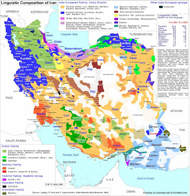
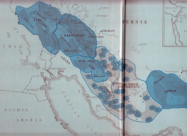
To clear things up a bit regarding where these weavings were made in relation to each other, it might help to have a map. I haven't found one which specifically shows all the tribes, their territories and migration routes, but here is a small version of a language map from a blog site on Iran news, Usowski on Iran:

To see the full size:
This shows a bit more clearly the wide dispersion of the Afshar, the vicinity of the Bakhtiari in the north, the Luri in the middle and how the Khamseh are stuck in between the southern Afshar and the Qashqai.
Print it off on a full size printer and tack it to the wall behind your computer as a handy reference!

Patrick Weiler
Wikipedia
To clear things up a bit regarding where these weavings were made in relation to each other, it might help to have a map. I haven't found one which specifically shows all the tribes, their territories and migration routes, but here is a small version of a language map from a blog site on Iran news, Usowski on Iran:

To see the full size:
This shows a bit more clearly the wide dispersion of the Afshar, the vicinity of the Bakhtiari in the north, the Luri in the middle and how the Khamseh are stuck in between the southern Afshar and the Qashqai.
Print it off on a full size printer and tack it to the wall behind your computer as a handy reference!

Patrick Weiler


